One other feature that Google Maps offers is data related to the pandemic. Whether you want to get information about your home location, somewhere your family lives, or a place you’ll be visiting, just open the Google Maps website. You can stay up to date on the number of new cases, confirmed cases, and more in your county, state, country, or region.
Get COVID-19 Data on Google Maps
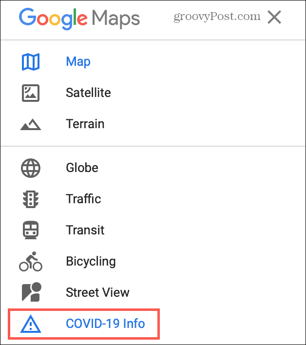
Viewing the data on the Google Maps website is easy. You can open a handy dialog box with information and keep it open as you move about the map. Click the Menu icon on the top left next to the Search Google Maps box and select COVID-19 Info.
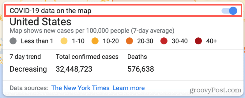
When the dialog box opens, you can hide the sidebar if you want a full view of the map with the data. Just make sure the COVID-10 data on the map toggle is turned on.
View Data by Location
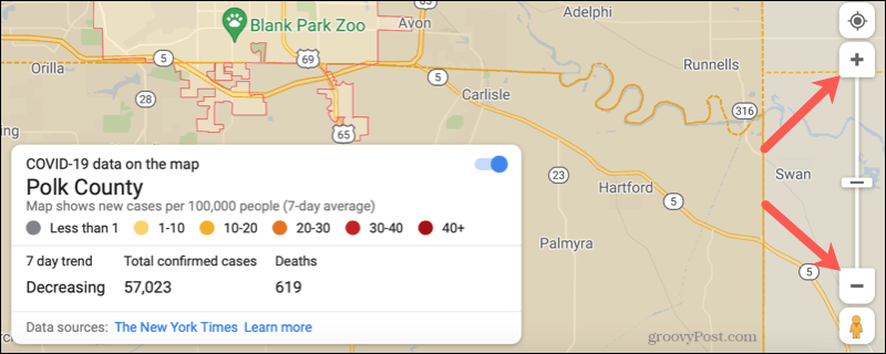
If you use Google Maps online regularly, then you know you can zoom in and out as well as pan by dragging. The COVID-19 dialog box will remain open as you move around the map, making it easy to view data by location. When you view locations in the United States, you can zoom in as far as a county. Use the plus and minus buttons or the zoom slider on the bottom right of Google Maps to zoom in and out.
Tip: If you zoom out as far as the tool lets you, you’ll see worldwide data.
Available COVID-19 Data
Here’s the data you can view about COVID-19 around the world using Google Maps. New cases: You’ll see a color-coded legend that displays new cases per 100,000 people on a seven-day average. The range goes from less than one to 40 and over. Seven-day trend: This shows either Increasing or Decreasing. Total confirmed cases and Deaths: These are total numbers for each and Confirmed Cases take into account both confirmed and probable cases in some places. Keep in mind that the sources of the data vary depending on location and thus the timing of the tracking. For example, if you’re viewing data in Illinois, you may see the data source is The New York Times while if you’re viewing a spot in India, you might see the data source is Johns Hopkins University.
Stay Up to Date on COVID-19 Cases Around the World on Google Maps
Without searching the internet to try and find the latest COVID-19 data in your area or one on the other side of the globe, check out Google Maps. For more, learn about COVID-19 tracing apps and what you need to know. Comment Name * Email *
Δ Save my name and email and send me emails as new comments are made to this post.


![]()
